A quick-moving clipper system moved through eastern North Dakota Monday 10/30/23 afternoon delivering a quick but heavy burst of snow. It is our fourth storm in this year’s LRC.
Starting in the Devils Lake Basin and Northern Valley late morning to early afternoon moving southeast, reaching the Fargo area by about 4:30 pm with snow showers lasting into the evening and some snow lasting into Monday night.

Snow came down at a quick rate, mixing with a southwest between 10-25 mph, causing visibility to fall to only a few hundred feet at times. Road and air temperatures were near the freezing mark. As more snow fell and melted on the roadways, along with snow blowing and drifting on the roadways, conditions very quickly deteriorated. Roads became ice-covered and snow-packed in areas, causing elevated driving conditions. The wind continued to increase on the back side of the Clipper System.By the evening, wind increased between 20-40 mph with gusts up to even a little stronger than 50 mph. The official highest wind gust at Grand Forks ND, was 50 mph while Fargo ND, reached 46 mph.
As winds increased throughout the evening, roads continued to deteriorate as drifting snow glazed over wet roads. Blowing snow wasn’t as much of an issue after the snow showers ended in the Southern Red River Valley. Northern Valley had a bit more snow on the ground so blowing and drifting snow continued to some degree. Travel alerts and no-travel advisories were issued as driving conditions reached dangerous and difficult levels in areas.

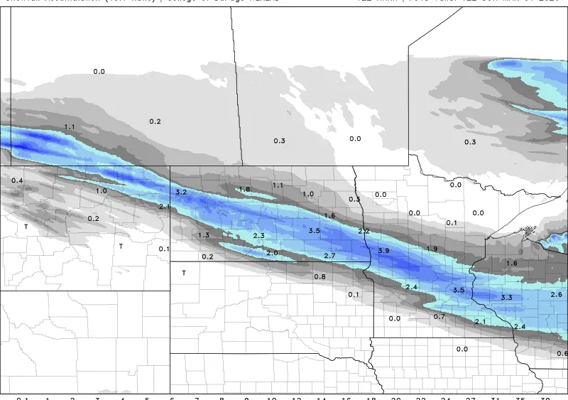
It wasn’t necessarily the snow amounts that led to the issues. It was the rate the snow fell at, the wind that accompanied it, temperatures near freezing, and the ‘warm’ roadways that got wet and then froze over. One to two inches of snow fell in eastern North Dakota and one to three in Minnesota with localized areas slightly higher.


Meteorologist,
Justin Storm