Forecasting is as much an art as it is a science. Which computer model is correct? Which one is closest? What model shows the closest to what I think will happen? These are all questions that meteorologists face when predicting the weather that will affect you, your friends, and your family’s plans. Reliability starts to tail off once you get past 7-10 days using most computer models. Depending on the model and observer… reliability could drop off just a few days down the road. But what if there was a way to predict the weather with the same accuracy as a 7-10 day forecast… Weeks and months into the future?
The Lezak Recurring Cycle (LRC) is just that. This “new” way of forecasting is a great tool to have and use when predicting what the weather may be like weeks and months down the road. When and where is it most likely to have a severe weather outbreak? When will the next winter storm hit? When is the next atmospheric river going to hit the West Coast? Will there be a drought? Will it rain on my wedding date? All these questions can be answered with the LRC. But how does it work?
The LRC is a new and different way of predicting the weather compared to traditional physics-based computer models. Simply put what has already happened will happen again, the LRC is based on a cycling weather pattern. Early October every year a new and unique pattern sets up ( Possibly due to the North Pole being in twilight from the Autumn Equinox until early October, after which it is in full darkness for the Winter. )
This weather pattern will typically last between 40-60 days but could be as short as 30 or as long as 70+ days. When trained in the LRC you can pick out key features in the upper air winds to determine how long these cycles are and then predict what the future will look like based on what has already happened. The Moon revolves around the Earth in a cycle. As does the Earth around the Sun which brings us our different seasons. Phases of the moon and tides go in cycles. There are so many cycles, why couldn’t the weather work in cycles?

Of course, the LRC is much more complicated than that, when put in very simple terms that’s how it works. Many things come together to make that possible such as influences on the LRC like El Nino and La Nina. These each play a role in what the weather is more likely to be like. But that is not the case every year. Look at California last year, predicted to be a dry winter simply based on La Nina. Record precipitation fell in areas of California and the Mountains that winter of 2022/2023 when all were calling for a drier winter except the LRC. I’m not saying that there’s no use or validity to what the weather will be like based on typical weather patterns during El Nino or La Nina, there is! But the LRC is the centerpiece of the forecasting puzzle.
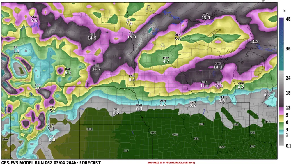
Take a look at a couple of predictions and examples of the LRC at work from this year so far. These are upper air maps at the 500 millibar level or approximately 18,000 feet aloft. The dips or troughs in the wind flow are storm systems. Let’s take a look at the Northern Plains First and then the West Coast Atmospheric Rivers, and Eastern US Storms:
Cycle two of this year’s LRC. Christmas, December 25, 2023, portions of North Dakota, South Dakota, and Minnesota were hit with a very significant ice storm that snapped hundreds of power poles in ND and cut off power for some for a week! Record rainfall hit portions of North Dakota, South Dakota, and Minnesota followed by ice accumulations of a tenth of an inch to three quarters of an inch…in spots of an inch or greater, and then light snow.

We forecasted another possibly impactful storm to hit the area approximately 45 days later around the 7/8 of February but likely not as significant as the Christmas Day ice storm. Sure enough, right on schedule another storm pounded into the West Coast, rode over the Rockies, and pushed into the Northern Plains bringing another round of record precipitation for the day, ice, and light snow. Not anything like the amount of ice seen in the prior cycle due to a much faster progression of the storm and the speed of the turnover from rain to snow but just enough to create some icy roads, especially as temperatures dropped below freezing with the wet roads from the rain and drizzle.

This portion of the LRC will cycle back through again around the 25th of March. Will it be all rain or will it be cold enough for snow? likely we will see a scenario similar to the past two. Starting as rain then turning over to snow on the backside of the storm with wind. You can follow along with our calendar where I have analyzed this year’s LRC to forecast for possible storms and weather up in the Northern Plains centering in Fargo ND.
Here is a link to the calendar.
Now for the West and East Coast:
During the first cycle of the years LRC the east coast was dealing with another storm after it had crossed the county while areas of the West Coast and the Pacific Northwest were preparing for another storm system offshore.

Cycle two, the east coast was hit with another storm while the West Coast prepared for another dangerous atmospheric river of moisture!


The Los Angeles Times wrote of the record rains and damage produced by the flooding and mudslides.
Using the LRC you could know that this was going to more than likely happen again to some degree and oh did it ever…
Here is a post from Gary Lezak, CEO and owner of Weather20/20, the man behind the LRC from the 20th of December of 2023.

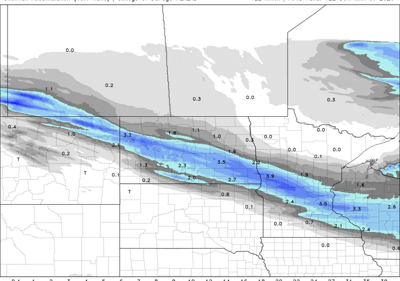
Coincidence that these storms hit in such a similar way? Maybe but a third time? Here is cycle three.


Be watching Mid-March for another big storm to hit the West Coast that will track across the country into the Northern Plains and or Great Lakes area.
Like all models, the LRC is not perfect but I have used it for the past three years and have been beyond impressed with its accuracy, as have our listeners. I’ve used it and have seen it yield outlooks months in advance for when and where severe weather outbreaks would hit, hurricanes, heat waves, and Arctic outbreaks. It’s truly an amazing tool to have when forecasting long-range.
Meteorologist,
Justin Storm